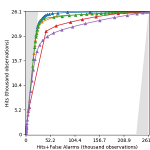
Close

Zhen Liu

University of Maryland PhD student

Download Resume

About Me

Currently, I am working in the Global Land Analysis and Discovery (GLAD) laboratory in the Department of Geographical Sciences at the University of Maryland. I qualified as a graduate in MSGIS from Clark University and a undergraduate in Geodesy and Geomatics from Wuhan University. My interests are landcover mapping, machine learning, deep learning, computer vision, and spatial data analysis. I love to code to make work efficient, convert ideas to products, and help people. My three characteristics are: learn fast, work hard, and think smart. Outside the raster and vector, I like movies, music, and traveling.

Experience

Shanghai Surveying and Mapping Institute

Summer Intern

  • Preprocessed images for land monitoring (feature detection, feature matching, and cloud screening).
  • Surveyed and scanned the metro station in Shanghai city, using total stations and 3D scanner.
  • Processed 3D point cloud for Shanghai Metro Line 10 using 3DReshaper.

Cloud to Street

Summer Research Fellow

  • Improve the accuracy assessment in the flood risk maps

Clark Labs

Research Assistant

  • Develop the open-source version of the website "Coastal Habitats and Conversion to Pond Aquaculture".

GLAD Laboratory

Graduate Research Assistant

  • TBD

Education

Clark University

Sept 2019 - June 2021

Master of Science (M.S.) in GIS (Geographical Information Science)

Wuhan University

Sept 2015 - July 2019

Bachelor of Engineering (B.E.) in Geodesy and Geomatics Engineering

Projects

TOC Curve Generator

TOC Curve Generator is a computer program to make TOC curves. Users can generate TOC curves from various file formats and customize TOC curves for research.

View Project

Tropical Pond Aquaculture and Coastal Wetlands Website

This project is mapping an inventory of pond aquaculture and coastal habitats in Bangladesh, Cambodia, Ecuador, India, Indonesia, Malaysia, Myanmar, Thailand, and Vietnam. I am working on the statistics display with interactive charts on the website.

View Project

Disaggregating Census Data in Somalia Using Random Forests

This project is to generate the gridded population map in 2018 in Somalia by using Random Forest and an improved method.

View Project

Spatio-temporal and Events Based Analysis of COVID-19 in Twitter

This project is to analyze the COVID-19 related tweets in 30 days in the US continent spatially and temporally.

View Project

Useful Executable Programs Developed in Python

The programs developed in Python to make daily work efficient. They helped to sample potential flood observations, search and update datasets, and inspect and categorize image chips.

View Project

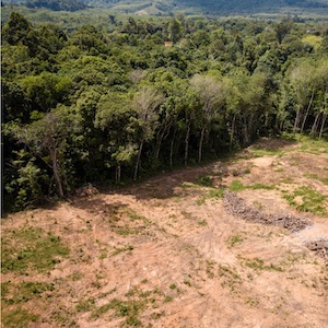
Mapping Forest Disturbance Across Amazon Basin using Phase Information from Sentinel-1 SLC

This project is using coherence information from SAR images to generate deforesation map. We compare the result with the existing deforestation products to see if changes in estimate coherence can complement changes in backscatter for deforestation monitoring, and hence strengthen deforestation detection using Sentinel-1.

View Project

Skills

Blogs

Get in Touch